Hollow Fields
During the spring thaw conditions on Perry’s Peak Road can deteriorate, making the trailhead at Hollow Fields difficult or impossible to reach. If you encounter poor road conditions (i.e. deep mud, ruts, erosion) on Perry’s Peak Road, please consider turning around and visiting another BNRC reserve. Please respect any “Road Closed” signs, and do not park on the side of the road or anywhere other than the BNRC trailhead for any reason. We ask this out of courtesy for our neighbors who need this road to access their homes.
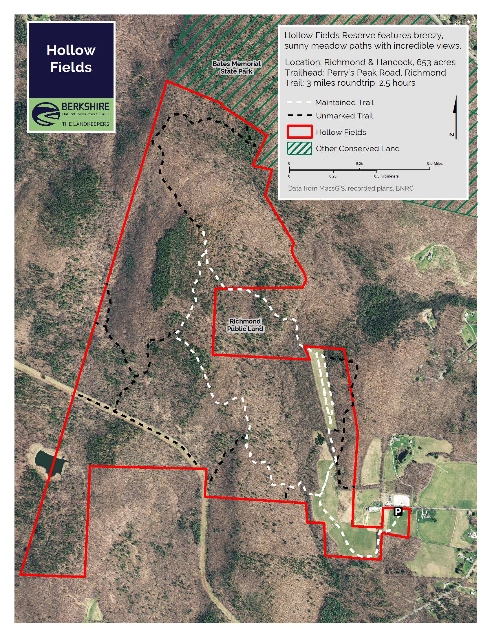
Walk mowed paths through open fields with views that are both sun-splashed and windswept, stunning in all seasons.
Highlights
- Richmond, MA
- About 6 miles of trails
- Difficulty: Moderate
- Size: 660+ acres
- Especially good in: Spring
- Special features: Open fields and scenic views great for bird watching and picnicking
This land, and all of the present-day Berkshires, are the ancestral homeland of the Mohican people, who were forcibly displaced to Wisconsin by European colonization. These lands continue to be of great significance to the Stockbridge-Munsee Mohican Nation today. To learn more, visit mohican.com.
Maps
Please wait, map is loading.
Directions & Parking
GPS
- Trailhead Parking: Google Maps | 42.4068, -73.3654
From Great Barrington
Take Route 41 north into Richmond. After passing Route 295, Perry’s Peak Road will be the next left approximately one mile down the road. On Perry Peak Road, find the parking on the left, with a BNRC sign by the road. Please do not park directly on Perry’s Peak Road in any season.
From Pittsfield
Get on West Housatonic Street (Route 20) heading west. Turn left onto Route 41 just before Hancock Shaker Village. After 2.5 miles turn right onto Perry’s Peak Road. Parking is signed, on the left. Please do not park directly on Perry’s Peak Road in any season.
From Lenox
Take Route 183 west towards Tanglewood. Just passed Tanglewood, turn right onto Richmond Mountain Road. Richmond Mountain Road becomes Lenox Road. Continue on Lenox Road through a few intersections and 3 miles. When you get to Route 41, turn right. After passing Route 295, Perry’s Peak Road will be the next left approximately one mile down the road. On Perry’s Peak Road, find the parking on the left, with a BNRC sign by the road. Please do not park directly on Perry’s Peak Road in any season.
Trail Description
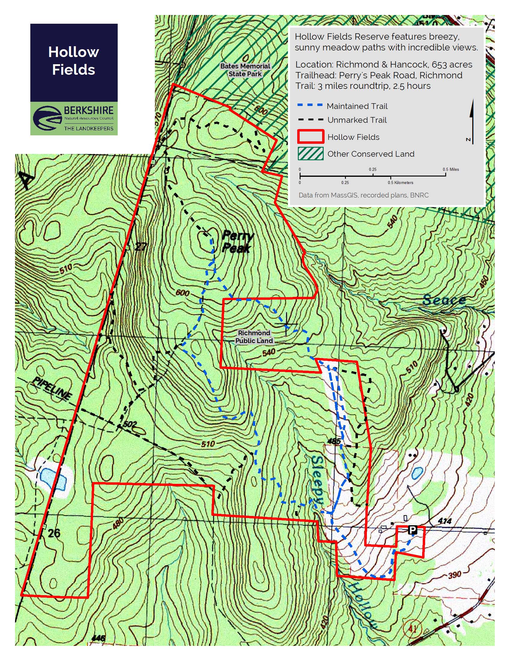
- Fields Trail: 2 miles, round-trip, 1 hour, moderate (smooth footing, elevation changes)
- Perry’s Peak Loop: 3.7 miles, round-trip, 2 hours, moderate (uneven footing, elevation changes)
Fields Trail
A mowed path that runs downhill from the barn. Without too much effort, a walk up through some of the 40 acres of fields provides a profile view of Yokun Ridge and a bench to enjoy it from. Higher up, there is a view of the crenellated hills of South Berkshire. After the summer haying season, the mowed path can sometimes be difficult to see. Trail blazes on the bluebird birdhouses mark the trail direction. From the trailhead to the most distant point of the uppermost meadow and back is about two miles.
Perry’s Peak Loop
Follows the mowed path from the trailhead. At the first intersection take a left into the woods to hike the loop clockwise toward Richmond Overlook (aka Scotty’s Lookout). Farther north, a short spur leads to the forested summit of Perry’s Peak. Both loop directions incorporate a steep climb along woods roads and a beautiful mix of forest types; including oak and beech, stands of red pine, and semi-open ridge tops bursting with ferns, old apple trees, and wild berries.
In the near future, trail connections will be made to Bates Memorial State Park and the Taconic Crest Trail.
About the Reserve
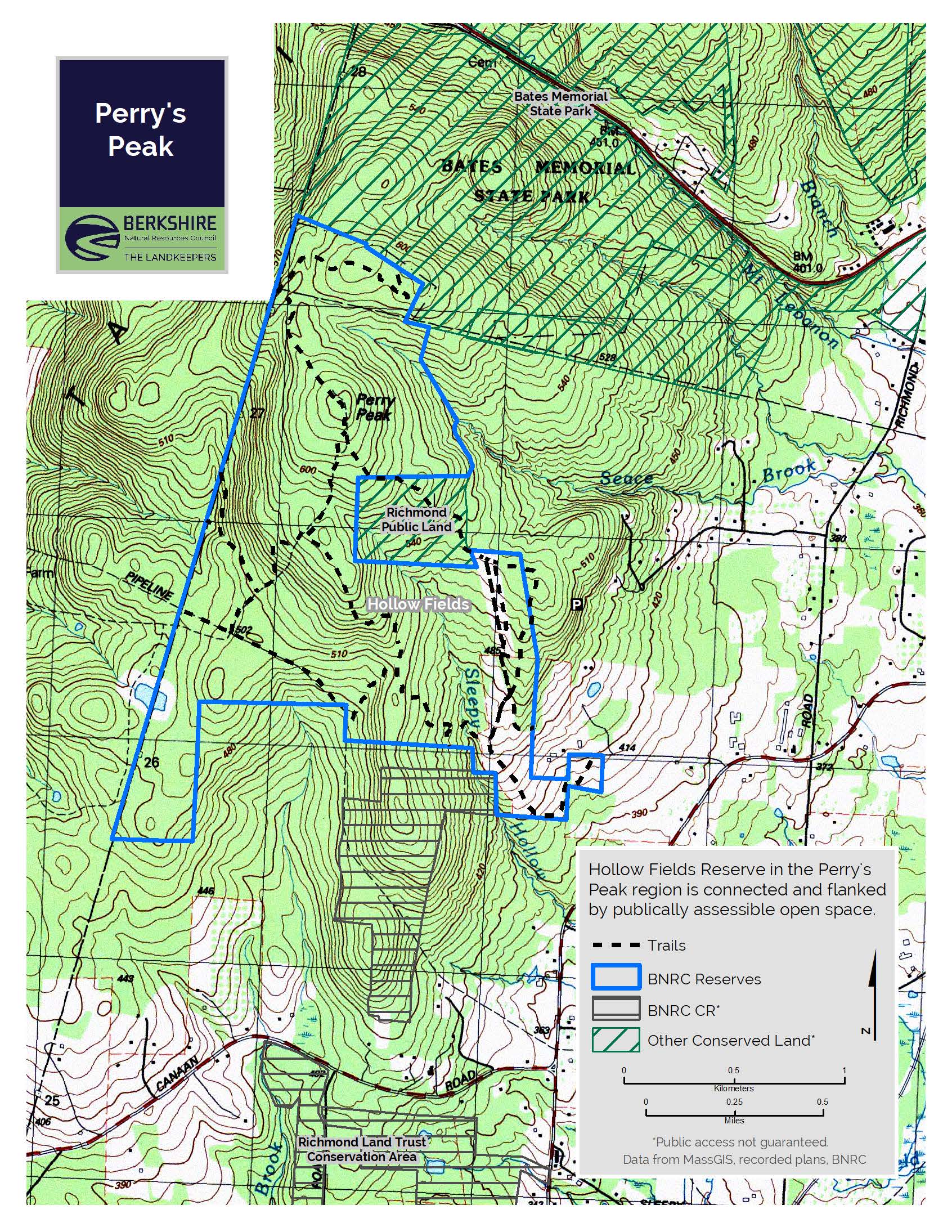
The 660+ acres of linked hayfields and forests of the Hollow Fields reserve offer the Berkshires’ best view of Yokun Ridge, and abundant bobolinks nesting in the grasslands. Enjoy walking the path through the fields or explore the trails and woods roads in adjoining forestland, including a 45-acre parcel owned by the Town of Richmond.
This land, and all of the present-day Berkshires, are the ancestral homeland of the Mohican people who were forcibly displaced to Wisconsin by European colonization. These lands continue to be of great significance to the Stockbridge-Munsee Mohican Nation today. To learn more visit mohican.com.
Prior to colonization, the present-day Berkshires were home to the Muh-he-con-neok, the People the Waters That are Never Still. The Mohican people gardened, hunted, and fished these lands. Europeans brought disease and war, which dramatically affected Indigenous People. Colonization forcefully displaced the Mohican people to Wisconsin, where today that community is known as the Stockbridge-Munsee Band of Mohicans.
Since European settlement of Richmond in 1765, the forests have come and gone as the land was cleared for agriculture, abandoned until the trees regrew, cleared again for charcoal to feed the former Richmond Iron Works, then abandoned, and so on. This is a common timeline of New England forests, resulting in the mostly forested landscape that you can see in the expansive views of Yokun Ridge to the east and south. The United Society of Shakers also owned some of the western land of Hollow Fields reserve at one time.
Thanks to the generosity of Ron and Judith Shaw, the hayfields to the south and west of this point are conserved and open to the public forever. Forty-five acres of town land are adjacent to the property and are open to the public as well. The most northern meadow abuts a wooded parcel that was originally donated to the town of Richmond by the Miller family, former owners of The Berkshire Eagle. Members of the family helped found the Berkshire Natural Resources Council in 1967. Acquisitions in 2016 and 2019 expanded Hollow Fields north and west to the New York State boundary, now linking 1,300 acres of conservation land.
Natural History
The fields host a variety of important and declining wildlife, including bobolinks and Savannah sparrows, which nest only in grasslands. Milkweed, a food source and habitat for monarch butterflies, is abundant in the fields. The scrub and young forest offer breeding sites for indigo bunting and eastern towhee.
The forest stands include northern hardwoods, spruce plantations, and some hemlock. Blueberries can be found in higher exposed areas.
The reserve protects the headwaters of several streams, notably Scace Brook and Sleepy Hollow Brook.