The High Road: Yokun Ridge & Connecting Trails

Explore the trails with outstanding vistas and diverse habitats. The entire route is open to hiking and crosses properties of several different owners and the allowed uses vary on those segments.
Highlights
- Pittsfield, Richmond, Lenox, MA
- Trail lengths: 0.4 to 9 miles
- Trail difficulty: Moderate to Difficult
- Special features: Outstanding vistas and diverse habitats
This land, and all of the present-day Berkshires, are the ancestral homeland of the Mohican people, who were forcibly displaced to Wisconsin by European colonization. These lands continue to be of great significance to the Stockbridge-Munsee Mohican Nation today. To learn more, visit mohican.com.
Maps
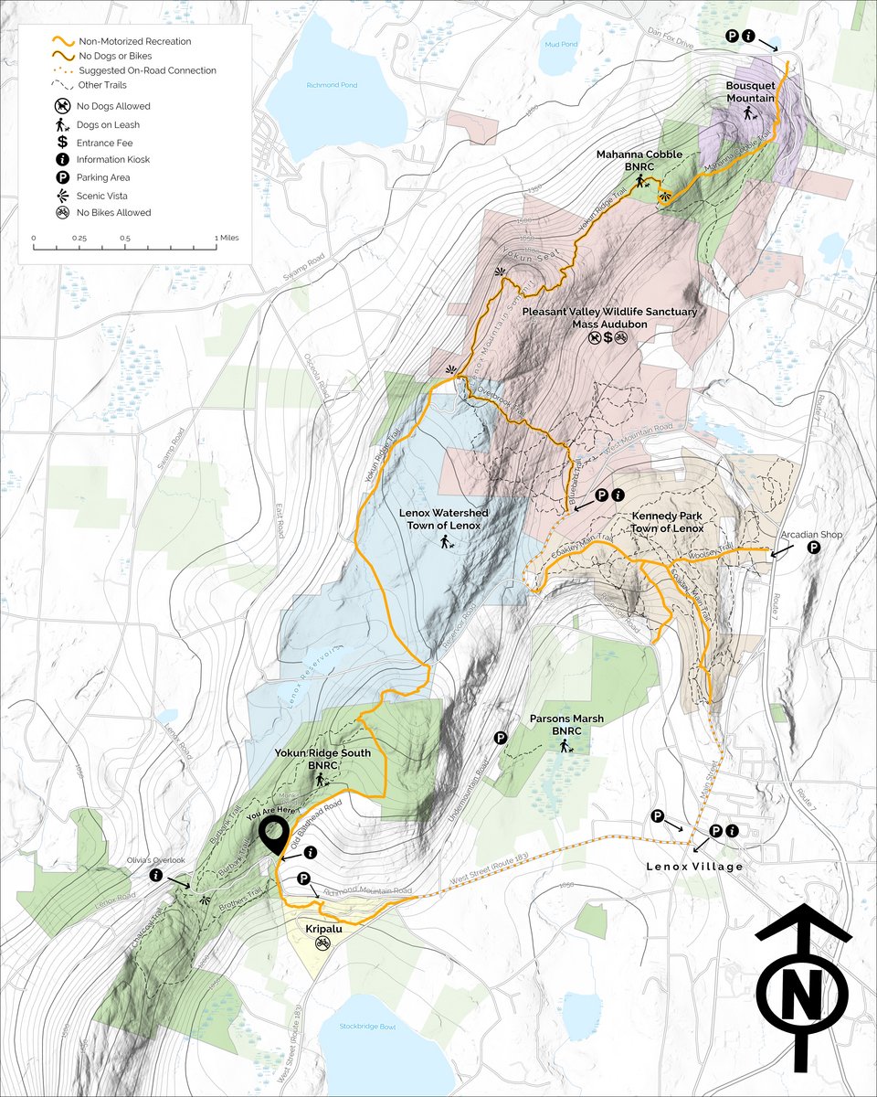
Paper maps are available at Mass Audubon’s Pleasant Valley Wildlife Sanctuary visitor center, the Mahanna Cobble trailhead at Bousquet Mountain, and the Brothers Trailhead at BNRC’s Yokun Ridge South reserve.
Trail Uses
- Enjoy this trail, which is best suited for hiking.
- Dogs and bikes are only allowed on portions of the route; through-hikers from Bousquet to Lenox may not bring dogs or bikes. Where dogs are allowed, they MUST be leashed and all waste removed. Please respect these landowners who have opened this trail for your enjoyment!
- Protect the trails, wildlife, and land. Carry out what you bring in, take only photos, and leave everything else just as you found it.
- Appreciate that this land provides a home, food, and shelter to wildlife and protection for clean drinking water. Respect wildlife and keep your distance.
Please wait, map is loading.
Trail Description
From the Mahanna Cobble Trailhead
Each mileage below is from the Mahanna Cobble Trailhead at Bousquet Mountain to that destination. All route mileage is one-way.
All route options are considered difficult due to length and/or elevation change
Hiking South
- Mahanna Cobble Vista: 1.6 miles
- Lenox Mountain Summit: 3.7 miles
- Pleasant Valley Wildlife Sanctuary: 4.9 miles
- Kennedy Park Trailhead at the Arcadian Shop: 7 miles
- Kripalu Center for Yoga & Health: 8.5 miles
- Lenox Village: Via Kennedy Park 8.25 miles; or Kripalu Center 10 miles.
The first section of the trail follows a route on Bousquet Mountain property. Use CAUTION when crossing active ski slopes in winter. Hiker signs direct you to the woodland start of the trail. From here, the Mahanna Cobble Trail is single-track with switchback turns and stone steps to the spectacular view and stone bench at the top. The bench is dedicated to Berkshire Natural Resources Council’s founding Executive Director, George Wislocki. If continuing south, please no dogs or bikes, due to sensitive habitats.
Enter Mass Audubon's Pleasant Valley Wildlife Sanctuary on the Yokun Ridge Trail to the expansive western facing view at Yokun Seat. This section encompasses open ridgeline as well as woodland trail and stone features. From Yokun Seat, continue the ridgeline experience with a moderate climb to the Lenox Mountain Summit.
Lenox Mountain offers hikers two route choices
Option 1: Venture down the Overbrook Trail and Bluebird Trails to Mass Audubon’s Pleasant Valley Wildlife Sanctuary visitor center. From here you can connect to Kennedy Park and the Lenox Village by road and trail (please note that this route does not have High Road signage on trail or road).
Option 2: From Lenox Mountain and leaving Mass Audubon's Pleasant Valley Wildlife Sanctuary, continue south along the Yokun Ridge Trail through the Lenox Watershed toward Reservoir Road and BNRC’s Yokun Ridge South Reserve. The designated High Road route is Old Baldhead Road. This connection takes you past Monks Pond to the Brothers Trailhead. The Burbank Trail offers an alternative route to Monks Pond and a connection to Olivia’s Overlook, a popular scenic vista.
Connections south into Lenox
From Old Baldhead Road (Brothers Trailhead), hikers should carefully cross Richmond Mountain Road to the Brothers Trail. After 0.1 mile, continue on the trail to Kripalu Center for Yoga & Health. There is parking for High Road hikers here. From Kripalu, hikers can follow a signed High Road route into Lenox Village by following West Street along a sidewalk. The Brothers Trail offers a diversion from the main High Road route, with water and stone features.
High Road routes within BNRC reserves, Pleasant Valley, Lenox Watershed, and Kripalu include wayfinding signage along the trails.
Each mileage below is from the Brothers Trailhead at Yokun Ridge South to that destination. All route mileage is one-way.
From the Brothers Trailhead at Yokun Ridge South
Each mileage below is from the Brothers Trailhead at Yokun Ridge South to that destination. All route mileage is one-way.
Hiking North
Unless otherwise noted, all route options are considered difficult due to length and/or elevation change
- Lenox Mountain Vista: 4.4 miles
- Pleasant Valley Wildlife Sanctuary: 5.6 miles
- Kennedy Park Trailhead at the Arcadian Shop: 7.7 miles
- Lenox Village: Via Kennedy Park 9 miles
- Mahanna Cobble Vista: 6.5 miles
- Bousquet Mountain Trailhead: 8.1 miles
Hiking South
These routes are considered moderate due to length and/or elevation change
- Kripalu Center for Yoga & Health: 0.4 miles
- Lenox Village: Via Kripalu Center 1.9 miles
Hiking North — Description
The first section takes hikers gradually up Old Baldhead Road passing Monks Pond and connecting to the Yokun Ridge Trail. The Burbank Trail at Monks Pond offers an alternative route to the Yokun Ridge Trail or Olivia’s Overlook, a popular scenic vista. The Yokun Ridge Trail leads to the Lenox Watershed and encompasses a moderate climb to the Lenox Mountain Summit. If continuing north or to Pleasant Valley Visitor Center, please no dogs or bikes, due to sensitive habitats.
Lenox Mountain offers hikers two route choices
Option 1: Venture down the Overbrook Trail and Bluebird Trails to Mass Audubon’s Pleasant Valley Wildlife Sanctuary vistor center. From here hikers can connect to Kennedy Park and the Lenox Villageby road and trail (please note that this route does not have High Road signage on trail or road).
Option 2: From Lenox Mountain, hikers may also continue north through Mass Audubon's Plesant Valley Wildlife Sanctuary along the Yokun Ridge Trail. This section encompasses a short, wooded ridgeline experience to the expansive western facing view at Yokun Seat. From Yokun Seat, continue along the ridge with a moderate descent with stone features to the Mahanna Cobble vista.
Follow the single-track trail with switchback turns and stone steps down to Bousquet Mountain property. From there, hiker signs and blue blazes direct you across a couple ski slopes and to the trailhead at Bousquet Mountain. Use CAUTION when crossing active ski slopes in winter.
Hiking South — Description
From Old Baldhead Road (Brothers Trailhead), hikers should carefully cross Richmond Mountain Road to the Brothers Trail. After 0.1 mile continue on the trail to Kripalu Center for Yoga & Health. From Kripalu, hikers follow a signed High Road route through the beautiful campus. High Road hiker parking is located at Kripalu or venture further on foot into Lenox Village by following West Street along a sidewalk. The Brothers Trail offers a diversion from the main High Road route, featuring water and stone features along the trail.
High Road routes within BNRC reserves, Pleasant Valley, Lenox Watershed and Kripalu include wayfinding signage along the trails.
About the Reserve
About The High Road
The High Road is a long-term, major conservation initiative of BNRC, made possible by generous donors and land partners. The High Road will make connections from towns to trails and along clusters of conservation land, allowing hikers to explore the scenic Berkshires. Through linked conservation lands along trails and walking paths, the High Road will connect pastures, fields, hillsides, and rocky crags with the places where we live and gather.
This is the first High Road Route to open.
Partners