
The High Road: Great Barrington Community Connector

Explore the trails with varied landscapes and diverse habitats. The entire route is open to hiking and crosses properties of several different owners and the allowed uses vary on those segments.
Highlights
- Great Barrington, MA
- Trail lengths: 0 to 5 miles
- Trail difficulty: Easy to Moderate
- Special features: Diverse habitats, access to downtown
Difficulty
This land, and all of the present-day Berkshires, are the ancestral homeland of the Mohican people, who were forcibly displaced to Wisconsin by European colonization. These lands continue to be of great significance to the Stockbridge-Munsee Mohican Nation today. To learn more, visit mohican.com.
Maps
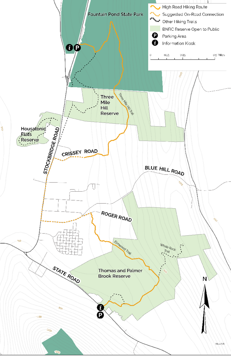
Paper maps are available at BNRC's Thomas & Palmer Brook Reserve trailhead and DCR's Fountain Pond State Park trailhead.
Trail Uses
- Enjoy this trail, which is best suited for hiking.
- Dogs and bikes are only allowed on portions of the route. Where dogs are allowed, they MUST be leashed and all waste removed. Please respect these landowners who have opened this trail for your enjoyment!
- Protect the trails, wildlife, and land. Carry out what you bring in, take only photos, and leave everything else just as you found it.
- Appreciate that this land provides a home, food, and shelter to wildlife and protection for clean drinking water. Respect wildlife and keep your distance.
Trail Description
From the Thomas & Palmer Brook Reserve Trailhead
Each mileage below is from the Thomas & Palmer Brook Reserve Trailhead to that destination. All route mileage is one-way.
All route options are considered moderate due to length and/or elevation change.
Hiking North
- 0.7 miles to Elmwood Trail
- 1.6 miles to Roger Road/ Blue Hill Road
- 2.8 miles to Threemile Hill Trail
- 5 miles to Fountain Pond State Park trailhead
The route begins at the Thomas and Palmer Brook Reserve trailhead, crossing a footbridge before winding through open field along the accessible Meadow Loop Trail. From there, it enters upland forest on the Woodland Trail.
At 0.7 miles, the route joins The High Road's Elmwood Trail.
At 1.6 miles, the trail follows Roger Road to Blue Hill Road, then on to Stockbridge Road, connecting visitors directly to downtown Great Barrington.
At 2.8 miles, the route turns off Stockbridge Road and onto Crissey Road (0.5 mi). After crossing the parking area and field at Berkshire South Regional Community Center (0.25 mi), it reconnects with BNRC’s Threemile Hill Trail and continues into the forest. From there, visitors cross streams and bog bridges along the base of the Threemile Hill ridgeline before reaching the northern terminus at Mass DCR's Fountain Pond State Park.
About the Reserve
The Great Barrington Community Connector is a 5-mile route from Thomas & Palmer Brook Reserve to Massachusetts Department of Conservation’s (DCR) Fountain Pond State Park in Great Barrington, that includes sidewalk along Stockbridge Road, enabling visitors to connect from trail to town.
About The High Road
THE HIGH ROAD is a long-term initiative of BNRC, made possible by generous donors and land partners. Primarily a recreational route for hikers, The High Road supports and complements many types of outdoor recreation while supporting local businesses that serve visitors and residents. The High Road broadens outdoor access for Berkshire communities by creating expanded trail connections through the region’s unique natural resources.
Partners
Generous support for the creation and stewardship of these trails and conservation of the land has been provided by Massachusetts Department of Conservation (DCR), Berkshire South Regional Community Center, and BNRC members.
The Elmwood Trail easement was supported by The Town of Great Barrington and funded in part by the Citizens of Great Barrington through the Community Preservation Act.