
JANE KAUFMAN — THE BERKSHIRE EAGLE Sep 8, 2026
GREAT BARRINGTON — Freshly painted dodger blue blazes mark the way from the Thomas & Palmer Reserve to Rogers Road in the woods behind Elmwood Cemetery on the newest mile-section of the Berkshire Natural Resources Council’s High Road.
The section officially opened Friday, allowing hikers to travel from State Road through the woods to Rogers Road. From there, hikers can use sidewalks along local roads to reach Berkshire South Regional Community Center and a trail running through Threemile Hill reserve to Fountain Pond State Park.
This is Berkshire Natural Resources Council's dodger blue blaze on the Elmwood Trail in Great Barrington. A trail crew painted the blazes last week in advance of the opening of the trail that runs between the Thomas & Palmer Reserve on State Road and Rogers Road near the intersection of Blue Hill Road.
The entire corridor is five miles long.
Known as the Great Barrington Community Connector, this path is the second Berkshire Natural Resources Council has opened as a part of its High Road network, which had an initial aim of creating 60 miles of linked trails throughout the Berkshires.
The High Road links towns to trails and other towns. The current goal is to create 30 miles by 2030. The first section opened in 2021 along Yokun Ridge in Pittsfield and Lenox.
A mini kiosk will give hikers a sense of where they are on the second section of The High Road. This one is near Rogers Road on the newly created Elmwood Trail in Great Barrington.
Starting from the Thomas & Palmer Brook Reserve on State Road, a hiker can make a wide loop through the reserve and then link to the new Elmwood Trail on town property. That new section of trail runs through young, even-age forest of mostly hardwoods, including cherry and red maple with white pine. The understory is rich in ferns but also has invasives, including burning bush.
The Elmwood Trail ends at Rogers Road near the intersection of Blue Hill Road.
Hikers can then use Rogers Road, Blue Hill Road and Stockbridge Road to walk to Crissey Road at Berkshire South Regional Community Center, which is adjacent to Threemile Hill reserve, then use Threemile Hill Trail, to walk to Fountain Pond State Park.
“One of the questions I’ve encountered is: why are we calling this assemblage of trails High Road right now?” said Doug Brown, director of stewardship for Berkshire Natural Resources Council.
Part of the answer lies in the linkages and the fact that the trails run across land owned by multiple owners, with Berkshire Natural Resources Council obtaining easements to create them.
Another component is their aim.
“Connecting people to new places and new places to people,” Brown said. “While this is just two trails with a little bit of trail that is connected by sidewalk, ultimately we are developing projects and opportunities that might allow us to connect elsewhere in Great Barrington and beyond as we work with partners and look at strategic land acquisition.”
He said the Great Barrington Community Connector will grow in the next decade, “if not sooner.”
Goals of the High Road are to both protect and allow access to its properties, while enhancing the Berkshires economy through recreation.
A sign on the newly created Elmwood Trail in Great Barrington points out mileage for hikers on this section of The High Road.
“Whether people are choosing to link multiple High Road routes together and stay at local lodging, bed and breakfasts in between segments or as they move from one spot to another, or if it’s just people adding these opportunities to their already planned visit to the Berkshires,” he said.
He said having a stretch of Route 7 be part of the route helps link the businesses, hospitality and lodging with the trail system.
All of the labor to create the Elmwood Trail was done this year, with staff from Berkshire Natural Resources and a crew from Greenagers building bog bridges to raise the trail off a wet area near Rogers Road.
Berkshire Natural Resources Council staff used a mini excavator to create the trail on the sloping terrain in young woods behind Elmwood Cemetery. The trail runs past boulders and winds through the woods. With leaves on the trees, the cemetery isn’t visible from the path.
The groundwork has been laid over many years, starting with a $5 million campaign to create the High Road in the mid 2010s.
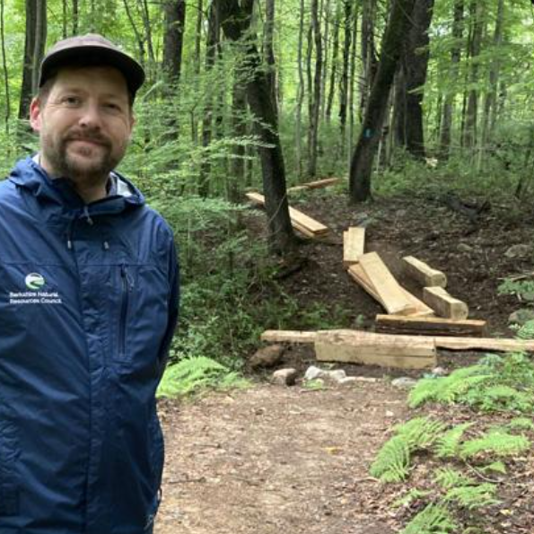
Doug Brown, director of stewardship at Berkshire Natural Resources Council, stands on the latest link in The High Road, the Elmwood Trail in Great Barrington. The trail is on town-owned land and is secured through a trail easement.
Great Barrington awarded Berkshire Natural Resources Council $40,000 in Community Preservation Act money in 2023 for work on Threemile Hill Trail, including creating bog bridges, restoring and improving bridges over streams.
In 2024, Great Barrington Town Meeting voters approved a permanent trail easement to Berkshire Natural Resources Council allowing construction and use of the Elmwood Trail. The town also allowed trail easements for use of the sidewalks along Blue Hill, Crissey and Rogers Road.
In 2025, the town again awarded Berkshire Natural Resources Council $24,800 in to do work on Elmwood Trail, including the creation of bog bridges.
Berkshire Natural Resources Council negotiated trail easements with the state Department of Transportation for the section along Stockbridge Road, also known as Route 7, and with the state Department of Conservation and Recreation for a section in Fountain Pond State Park as well as Berkshire South Community Center, which partnered in this project.
Brown estimated total cost at more than $100,000 to create the Elmwood Trail and to improve Threemile Hill. Costs include equipment, materials, staff labor and labor by Greenagers, who built bog bridges and kiosks for the trails as well as shoring up areas of trail with stone where there are drainage dips.
The trail has mini kiosks with maps and mileage at midpoints built by Berkshire Natural Resource Council trail staff as well as a full-scale kiosk built by Greenagers at the Thomas & Palmer Reserve.
Local and regional lumber milled by Konkapot Tree and Timber in Sheffield was used to build the bog bridges. The kiosks used both pressure treated and local lumber.
In creating the High Road, one of the aims was to protect land beyond the boundaries of the 28,000 acres that Berkshire Natural Resources Council protects in Berkshire County.
But there’s something else.
“In addition to just the long-distance hiking opportunities, we really see this as creating more localized opportunities,” Brown said. “We know from trail counters that Thomas & Palmer is one of, if not the most visited reserve in our portfolio. And so adding another access point into this landscape for the folks who live in this neighborhood will bring a lot of those local benefits too.”
Jane Kaufman is a News Reporter at The Berkshire Eagle. She can be reached at jkaufman@berkshireeagle.com or 413-496-6125.