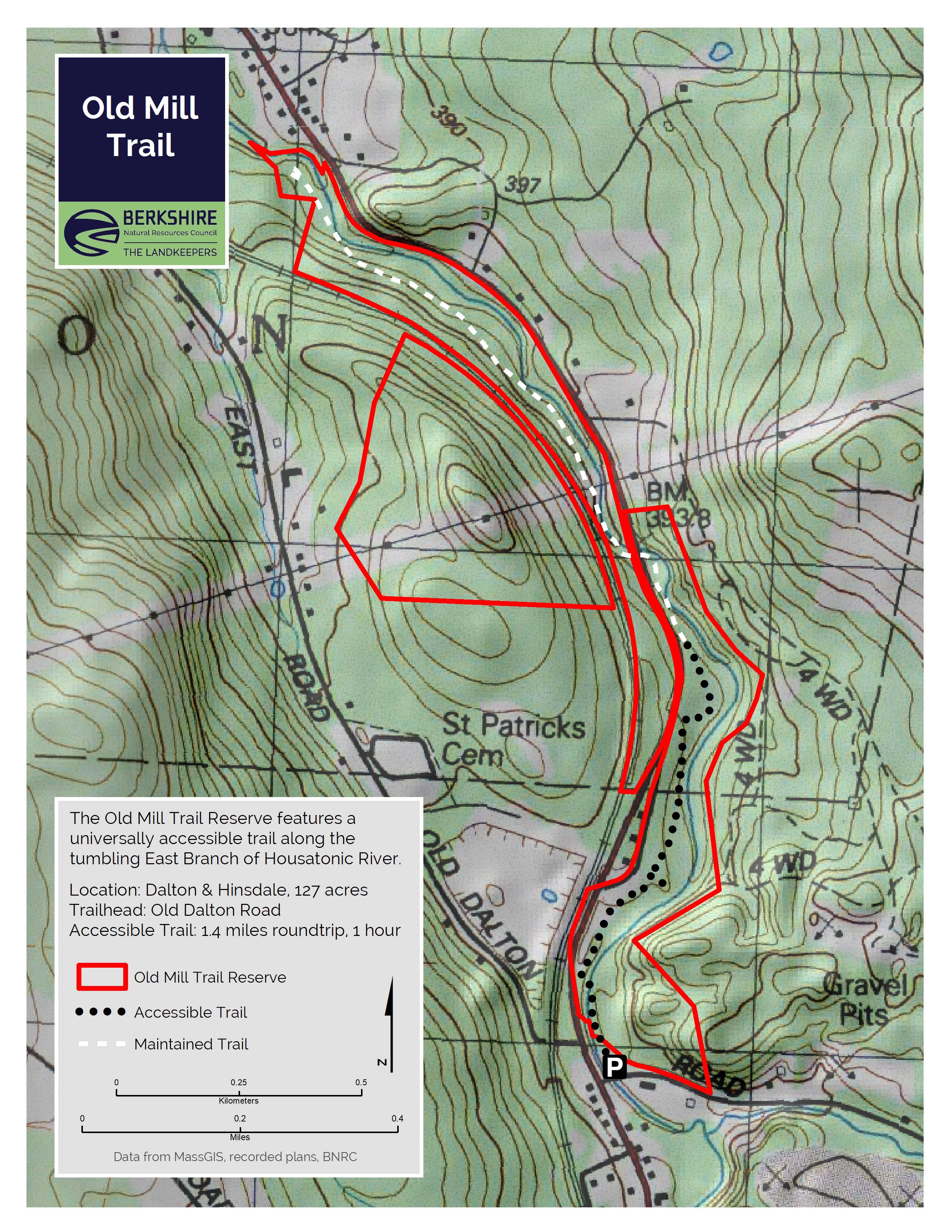
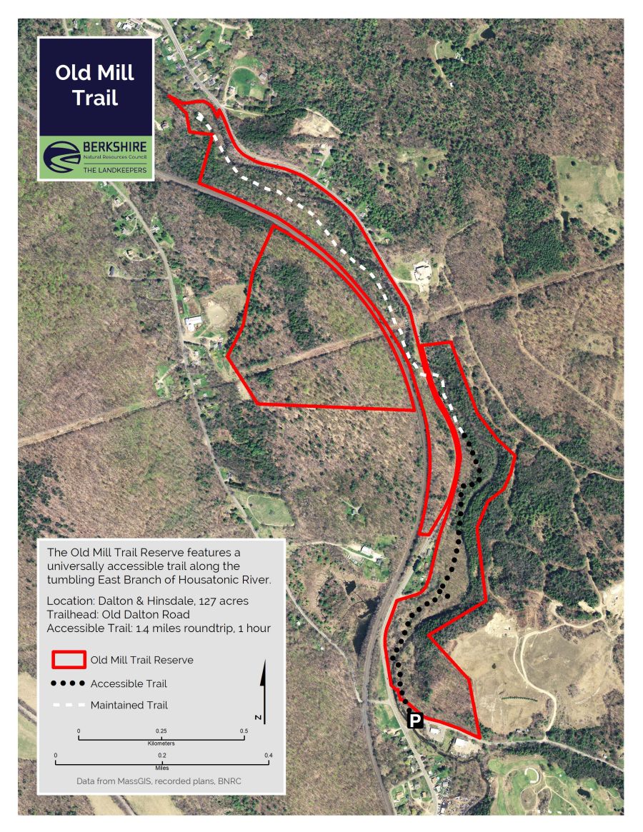
Old Mill Trail
Please Note: The parking lot and portions of the trail meet Forest Service Trail Accessibility standards, and are accessible for wheelchairs, strollers, and other mobility devices.
The Old Mill Trail is your best way to get at the upper reaches of the Housatonic River.
Highlights
- Dalton and Hinsdale, MA
- Entire trail: 3 miles
- Accessible section: 1.4 miles
- Difficulty: Accessible to easy
- Size: 127 acres
- Especially good in: Spring/Summer
- Special features: fishing access and interpretive trail
This land, and all of the present-day Berkshires, are the ancestral homeland of the Mohican people, who were forcibly displaced to Wisconsin by European colonization. These lands continue to be of great significance to the Stockbridge-Munsee Mohican Nation today. To learn more, visit mohican.com.
Directions & Parking
GPS
- Trailhead Parking: Google Maps | 42.4480, -73.1305
From Dalton Center
Take Route 8 south to the Hinsdale line. From the town line, continue 4/10 miles to a left on Old Dalton Road. The trailhead parking is the first, immediate left.
Accessible Trail
The parking lot and portions of the trail meet Forest Service Trail Accessibility standards.
Width: 36 inches – 60 inches
Cross Slope: 0-5%
Grade: 0-11%
- The trail is between 36 and 60 inches, the first half of the trail is mostly 36 inches.
- Most of the trail has a cross slope of 0-2%
- 65-foot bridge, 46.5” wide
- 8% grade for 22 feet on near side of bridge
- 7% grade for 11 feet on far side of bridge
- 18-foot bridge
- 8% grade for 10 feet on near side of bridge
- 10% grade for 12 feet on far side of bridge
- 40-foot bridge
- 6% grade for 10 feet on near side of bridge
- 10.5-foot bridge on the spur trail to the dam
- 5% grade for 6 feet on the near side of bridge
- 8% grade for 6 feet on far side of the bridge
- At approximately ¾ mile, there is a 120-foot section of trail that starts at 11% grade for 15 feet. The following 105 feet is at a 10% grade.
Trail Description
Accessible section (includes parking lot): 1.4 miles roundtrip, 1 hour
Entire trail: 3 miles roundtrip, 2 hours
The first 0.7 miles of the Old Mill Trail is a flat, gravel trail that follows the river north to a bench platform. Continuing on the Old Mill Trail is a narrow hiking trail for 0.8 miles, crossing Route 8 and following the river downstream. After the Route 8 crossing, the first several hundred feet of beautifully crafted trail is at the river’s edge. The entire trail, out-and-back, is 3 miles and offers great views of the East Branch of the Housatonic River. This trail connecting the communities of Dalton and Hinsdale, blends nature’s beauty with the history of the local nineteenth-century textile mills. The Old Mill Trail was designed and constructed by Peter S. Jensen & Associates, LLC.
There is also an interpretive trail that was installed by the Housatonic Valley Association, which highlights the natural history and mill history. There are two ways to experience the trail: you can grab a paper brochure at the trailhead or view the augmented reality videos.
About the Reserve
The Old Mill Trail of 127 acres is your best way to get at the upper reaches of the Housatonic River. Crane and Company conserved the land with MassWildlife and collaborated with the Housatonic Valley Association to build the trail. The Housatonic River suffers image problems due to PCB contamination south of Pittsfield, but the East Branch is clean and fast-flowing as it descends from Hinsdale. This accessible trail is a treat for trail users of all abilities. Travel past the end of the accessible section and across Route 8 for a pathway right at―and even in―the water’s edge.
The Old Mill Trail was an idea that came out of an East Branch Stream Assessment in 1999. Over 10 years and multiple grants, the Housatonic Valley Association (HVA) coordinated the design and construction of the Old Mill Trail with support from the property owner, Crane & Company, and MassWildlife. Many volunteers worked to lay out the trail from 2000 - 2009. Final construction was completed in 2010 with funding support from the Natural Resources Damages Fund and the skill of Peter S. Jensen & Associates, LLC, professional trail crew builders. BNRC acquired the land in 2016.
The Housatonic River has a rich history. Native Americans used this area for fishing and hunting for about 10,000 years. The Mahicans, who were the last tribe to live here, called the Housatonic River, Hoo-es-ton-nuc- “the place beyond the mountains.” However, disease, wars and the European demand for land ownership gradually forced the Native Americans out of the area.
European settlement began in earnest after the end of the French and Indian War in 1759. Early settlers harnessed the river’s swift current for water power. Ruins of many mills are all that remain along the riverbank, including a breached dam, stone foundations and remnants of an impressive penstock—the channel that conveyed water to the mill.
Natural History
Visitors and residents alike are drawn to the Housatonic River because of its natural beauty and recreational opportunities. The 149-mile river begins its journey to Long Island sound with its three headwater branches. The East, West, and Southwest Branches meet in Pittsfield to form the main stem of the Housatonic River.
The plants growing along the trail include Hemlock trees that prefer moist, cool ravines near the water. The shade they provide encourages growth of shrubs such as hobble bush, with white flowers in spring. Cottonwoods, ash, willow, and silver maple along with shrubs such as honeysuckle and gray-stemmed dogwood tolerate the floodplain environment.
The plant communities create specific wildlife habitat. Barred owls and red squirrels, chickadees and brown creepers favor groves of evergreens. Songbirds such as song sparrows share the floodplain with voles, hawks, and muskrat. Other wildlife, such as mink, coyote, bear, deer, and pileated woodpeckers can be seen in many riverside habitats.