Thomas & Palmer Brook
Wind through old pasture, a wetland, and mature forest to a dramatic high point of exposed bedrock.
Highlights
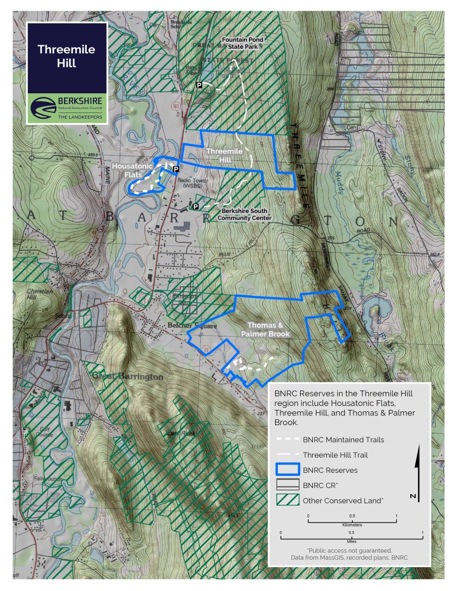
- Great Barrington, MA
- 2 miles of trails
- Accessible section: 0.5 miles
- Difficulty: Accessible to moderate
- Size: 333 acres
- Especially good in: Spring/Summer/Fall
- Special features: Gorgeous views across wetlands, large sugar maples, geology
This land, and all of the present-day Berkshires, are the ancestral homeland of the Mohican people, who were forcibly displaced to Wisconsin by European colonization. These lands continue to be of great significance to the Stockbridge-Munsee Mohican Nation today. To learn more, visit mohican.com.
Maps
Please wait, map is loading.
Directions & Parking
GPS
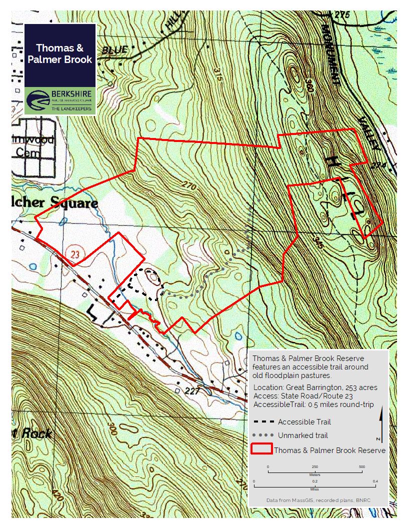
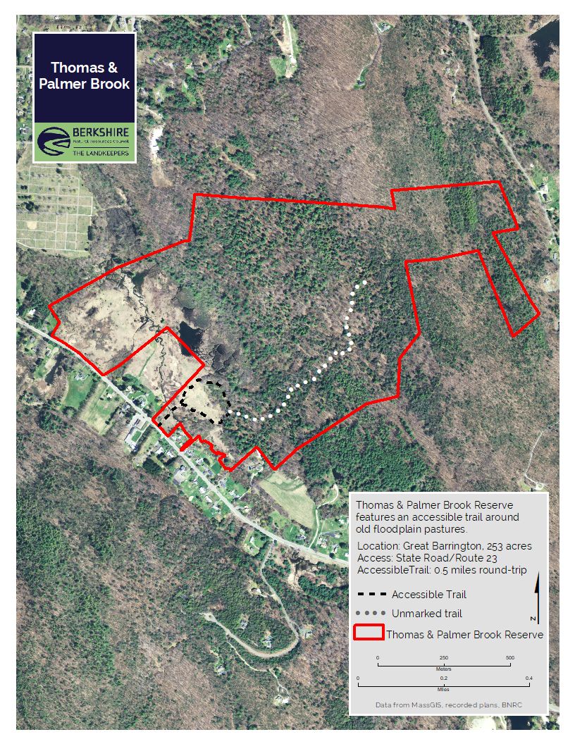
- Trailhead Parking: Google Maps | 42.1955, -73.3370
Parking
The parking area is located at 305 State Road (Route 23) in Great Barrington across from the Koi Restaurant.
Accessible Trail
The Meadow Loop was designed and built in 2020 to U.S. Forest Service Trail Accessibility Standards. The trail is approximately 0.5-mile of 6-foot-wide crushed stone surfacing with a running slope not exceeding 8% and cross slope not exceeding 5%. There are two benches and viewing areas overlooking a wetland and meadow.
- 90-foot bridge with 20-foot approaches at 6% grade, 7 feet wide, and 50-inch-tall railing. Some of the wooden boards on the bridge are warped with step ups < ¾ inch
- A few sections of 8% grade along the trail <14 feet long
- 7% grade halfway around the trail (0.25 miles) for 100 feet
- The gravel parking area has two designated accessible parking spaces.
Trail Description
From the trailhead, the path crosses a bridge that spans Thomas & Palmer Brook, a tributary of the Housatonic River.
- Meadow Loop: 0.5 miles, round-trip; Accessible (gentle slope, gravel surface)
- Woodland Trail: 0.6 miles, one-way; Moderate (uneven footing, elevation changes)
- Whale Rock Trail: 0.3 miles, one-way; Moderate (uneven footing, elevation changes)
Meadow Loop
This trail descends into a field where hikers can choose which direction to take on the loop trail. Heading counter-clockwise the trail winds along the woodland edge and through the forest. It continues around a knoll that is an old apple orchard. On the western side of the knoll, the path crosses between two large sugar maples and two large boulders before emerging back into the meadow. Along the way, take the opportunity to rest on one of the benches, and enjoy the expansive view of the wetland habitat.
The Meadow Loop was designed and constructed by Peter S. Jensen & Associates, LLC.
Woodland Trail & Whale Rock Trail
Located off the east side of the accessible trail and winds through the upland forest. At 0.6 miles the route transitions to the Whale Rock Trail, which gradually climbs to a unique rock feature, known locally as Whale Rock. Whale Rock is home to sensitive and unique habitats. Please protect this important area by staying on the trail at its endpoint.
The Woodland Trail and Whale Rock Trail were designed and constructed by BNRC staff with construction support from BNRC volunteers, Greenagers, and the Student Conservation Association.
About the Reserve
The 333 acres of the Thomas & Palmer Brook reserve slope upward from the brook through old pasture, a wetland and mature forest to a dramatic high point of exposed bedrock. An accessible trail through the meadow leads into the forest, winding past boulders and large sugar maple trees. The wide Woodland Trail climbs through the forest, leading to a narrow hiking trail ending at Whale Rock.
The Thomas & Palmer Brook reserve, established in 2015, is on the south-western slope of the Threemile Hill ridge that is a backdrop to much of Great Barrington’s commercial activity. Much of the land comprising the reserve was farmed well into the last century. The property is part of a habitat corridor reaching from Monument Mountain Reservation, Housatonic Flats, and Fountain Pond State Park in the west to the Butternut Ski Area and Beartown State Forest in the east. Keeping the entire contiguous corridor protected is important for wildlife and climate resiliency.
BNRC envisions the site as an anchor for future conservation along the Threemile Hill ridge, and for connected hiking routes as part of The High Road, an effort underway to connect trails and conservation to towns throughout the Berkshires.
Natural History
The old pasture is now dense with pollinator-loving goldenrod and milkweed. The forest consists of mixed hardwoods, white pine and hemlock. Beaver activity is visible near the brook and wetland. Birds that have been attracted by the property’s diverse habitats include the American woodcock, the blue-winged warbler, the chestnut-sided warbler, the eastern towhee and the purple finch. The property offers excellent conditions for wood turtles. The Thomas and Palmer Brook corridor has been identified as core habitat by Natural Heritage, meaning it is a habitat that could have rare, vulnerable, or uncommon mammal, bird, reptile, amphibian, fish, invertebrate, and plant species.
A habitat restoration project in 2018 and 2019 removed invasive species in the apple orchard and surrounding area. The Whale Rock feature is a metamorphic rock, which formed from high heat and pressure during the mountain-building process 540 million years ago.
