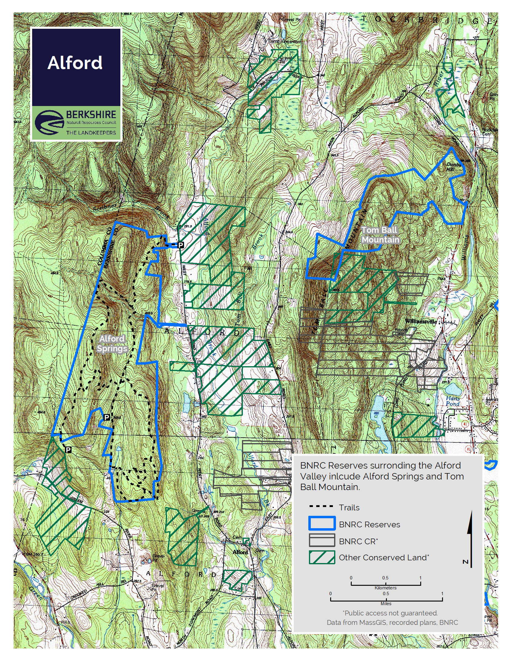
Alford Springs
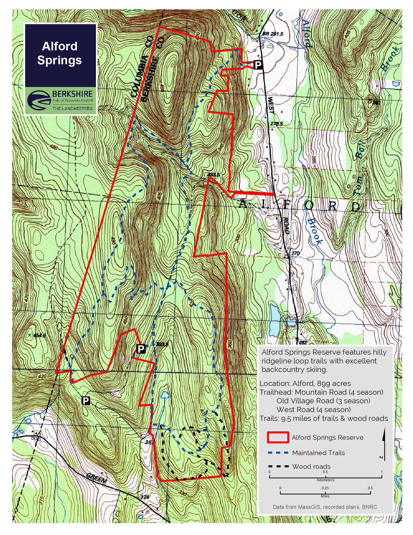
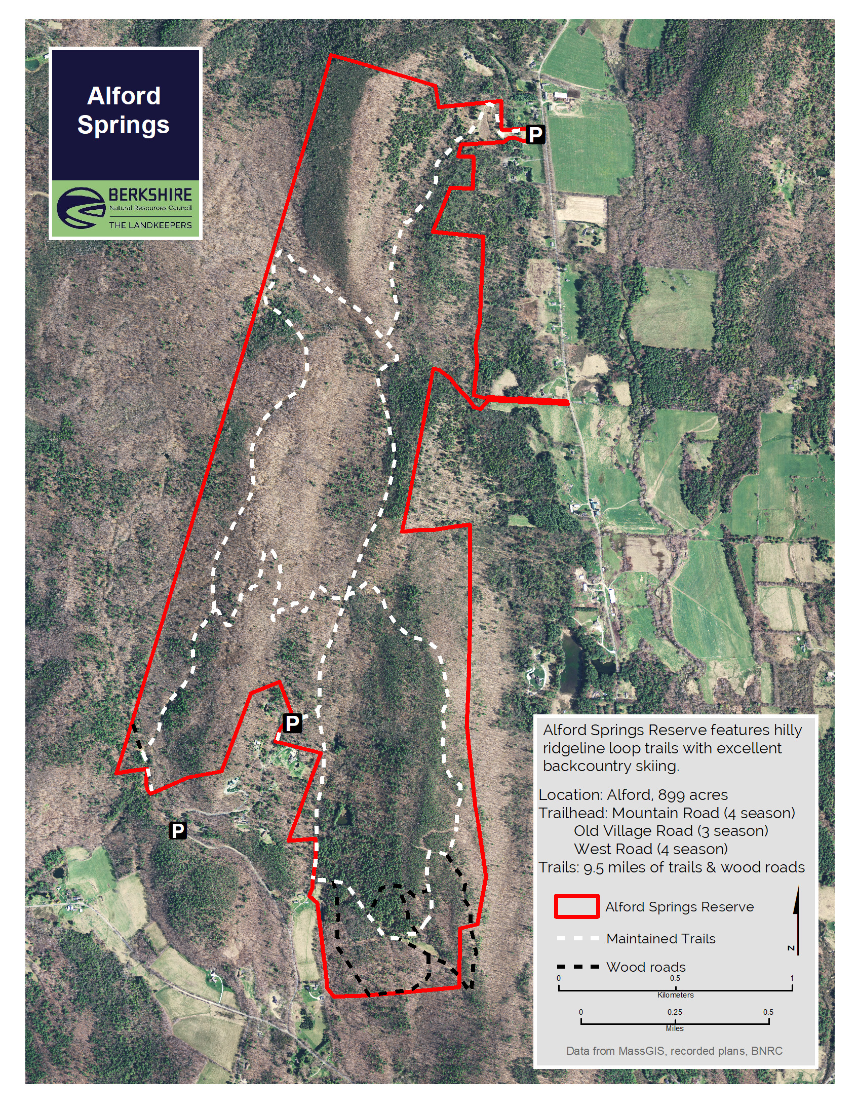
The Mother Loop Trailhead is three-season access only and closed in winter. Parking on Old Village Road is prohibited. Please respect the neighbors and refrain from parking on the road.
The Father Loop Trailhead and Saddle Trailhead can be accessed in winter.
During the spring thaw conditions on Old Village Road/Mountain Road can deteriorate, making the trailheads at Alford Springs difficult or impossible to reach. If you encounter poor road conditions (i.e. deep mud, ruts, erosion) on Mountain Road, please consider turning around and using the Saddle Trailhead on West Road or visit another BNRC reserve. Please respect any “Road Closed” signs, and do not park on the side of the road or anywhere other than the BNRC trailheads for any reason. We ask this out of courtesy for our neighbors who need these roads to access their homes.
Mostly forested ridgeline for hikers, snowshoers, seasoned cross-country skiers, mountain bikers, hunters and berry-pickers.
Highlights
- Alford, MA
- 1 to 7 miles of trails
- Difficulty: Moderate to difficult
- Size: 899 acres
- Especially good in: Winter
- Special features: Blackberries in summer and noteworthy backcountry Nordic skiing in winter. Gorgeous views of Alford Valley and good hunting reported.
This land, and all of the present-day Berkshires, are the ancestral homeland of the Mohican people, who were forcibly displaced to Wisconsin by European colonization. These lands continue to be of great significance to the Stockbridge-Munsee Mohican Nation today. To learn more, visit mohican.com.
Maps
Please wait, map is loading.
Directions & Parking
Father Loop and Mother Loop Trailheads
GPS
- Father Loop Trailhead: Google Maps | 42.2482, -73.4458
- Mother Loop Trailhead (3 season): Google Maps | 42.25240, -73.43861
From Great Barrington:
Take Taconic Avenue, which becomes Alford Road. Drive past Simon’s Rock to a left on Seekonk Road; follow Seekonk Road (becomes Green River Road) for 3.6 miles. Turn right on to Mountain Road (if you come to the New York State line, you’ve gone too far). Follow Mountain Road for 0.8 miles, bearing left at the first “Y” and left again at the sharp right turn at 0.8 miles. Alternatively, for the Mother Loop Trailhead, continue right to reach a second, three-season parking lot further down the street.
From Pittsfield:
Take Route 20 West and turn left onto Route 41 heading south. Drive to Great Barrington and turn right onto Division Street which becomes Seekonk Road. Turn right onto Seekonk Road which becomes Green River Road, turning right on Mountain Road (if you cross the NY state border you have gone a little too far. Follow Mountain Road for 0.8 miles, bearing left at the first “Y” and left again at the sharp right turn at 0.8 miles. Alternatively, for the Mother Loop Trailhead, continue right to reach a second, three-season parking lot further down the street.
Saddle Trailhead
GPS
- Saddle Trailhead: Google Maps | 42.274919, -73.427083
From Great Barrington:
Take Taconic Avenue, which becomes Alford Road for roughly 4 miles. Turn left onto Alford Center Road for 0.2 miles. Continue onto West Road for 2.8 miles. The trailhead will be on your left.
From Pittsfield:
Take Route 20 West and turn left onto Barker Road which becomes Swamp Road for 9.5 miles. Turn left onto MA-102 E/MA 41-S for 0.3 miles before turning right to stay on MA-41 S. In 2.1 miles turn right onto East Alford Road. Continue on East Alford Road to West Center Road (1.7 miles). Turn right onto West Center (0.6 miles), take a sharp left onto Wilson Road (0.6 miles), and continue onto West Road (1.7 miles). The trailhead will be on your right.
Parking
The trails are accessible year-round from trailheads with parking on Mountain Road and West Road. During every season but winter the Reserve can be accessed from a parking area at the end of Old Village Road.
Trail Description
Visitors can choose from a buffet of options:
- Father Loop: 4.3 miles, round-trip, 3 hours, difficult
- Mother Loop: 2.4 miles, round-trip, 1.5 hours, moderate
- Saddle Trail: 1 mile, one-way, 0.5 hours, moderate
Father Loop
The Father Loop has vistas to the north, south, and east. It is primarily a woods road and is lined with paper birch trees on the west ascent. In 2016, a 25-acre forestry project on the Father Loop created early successional habitat along with excellent views of Mt. Greylock.
Mother Loop
The Mother Loop offers a more traditional hiking trail, under dense canopy and with a view to the east. Hikers can also explore an old foundation, and open field with apple trees. Note: No winter maintenance.
Saddle Trail
The Saddle Trail begins by crossing a wet meadow and ascends the east slope of the Taconic Range on what might have been a driveway had BNRC’s supporters not conserved the property. From the would-be house site, there is a bench and a nice view of Tom Ball Mountain to the east. The trail utilizes a small saddle in the topography, winding through hemlock forest and past old stone walls and paddocks to connect to the Father Loop.
Unmarked Trails
The southeast corner of the property also has unmarked wood roads. Skiers should note that the trails and roads are not groomed and some can be challenging for beginners.
About the Reserve
Did you ever wonder what lies in that shadowy mountainous border region between the Berkshires and New York State? Not many roads traverse this frontier, and the steep, heavily forested slopes don’t immediately attract the casual visitor. But you might be surprised if you venture that way. The Alford Springs Reserve, 899 acres of mostly forested ridgeline, has more than seven miles of trails for hikers, snowshoers, seasoned cross-country skiers, mountain bikers, hunters and berry-pickers. The reserve, named for feeder streams of Alford Brook and the Green River, offers vistas of Greylock and Tom Ball mountains and Alford Valley.
The reserve lies on the eastern side of the Taconic Mountains, a chain that runs north-south along the Massachusetts-New York border. The Taconics were created 440 million years ago by a tectonic collision of the North American plate with a volcanic island chain. The local valley regions on either side of the mountain ridge are underlain with limestone. Quarrying of marble was a significant industry in Alford in the 1800’s. Alford marble, prized for its color, was used in building the New York City Hall.
This land has been more hospitable to wildlife than humans. There are cellar holes, remains of barns or outbuildings, and stone walls on the property, mostly abandoned in the 19th century. These structures represent the past agricultural history of the area. “Sheep fever” took hold of New England between 1810 and 1840 and resulted in 8o% of forests being cleared for pasture or hayfield. 1837 was the peak year of sheep in Berkshire County with 136,000 sheep and 40,000 people. By 1900, more than half of the cleared land was becoming reforested.
In the 1970’s Old Village Road was developed, and much of the current reserve was surveyed to become phase two of the subdivision. Luckily, the market slowed and BNRC, in partnership with MassWildlife, was able to acquire the land for conservation. Between 2002 and 2018, BNRC acquired parcels to piece together the current reserve.
Natural History
In 2016, a 25-acre forestry project on the Father Loop created early successional habitat along with excellent views of Mt. Greylock.
Wild berries are abundant at Alford Springs, which is one reason you may see sign of bear. Deer and bobcat also frequent the reserve. Hardwoods here include northern red oak, white oak and chestnut oak, as well as beech, black birch and red maple. There are American chestnut saplings that have not yet succumbed to the chestnut blight. What was once pastureland now has stands of a variety of trees, including white pine.
A cold water brook and several intermittent streams tumble down from Alford Springs to feed Alford Brook, a cold water fishery of high water quality. Alford Brook joins the Green River and eventually the Housatonic. The Green River is known for its water quality and trout fishing.