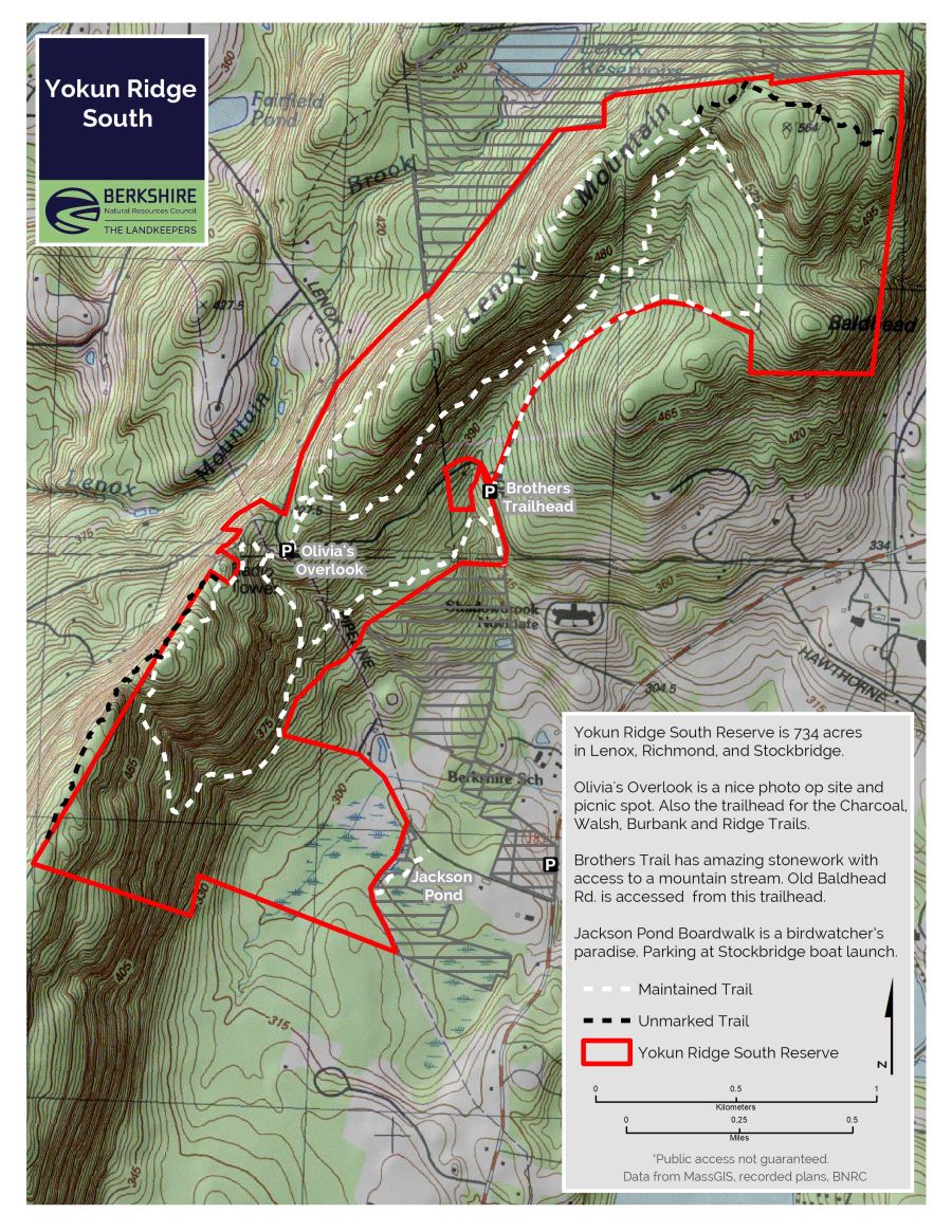
Olivia’s Overlook at Yokun Ridge South
Olivia’s Overlook is at the center of the Yokun Ridge South reserve and connects to The High Road route.
Highlights
- Lenox, Richmond, Stockbridge, and West Stockbridge, MA
- Over 6 miles of trail
- Difficulty: Moderate
- Size: 734 acres
- Especially good in: Fall
- Special features: Great views, Monks Pond, spring wildflowers, mountain laurel
This land, and all of the present-day Berkshires, are the ancestral homeland of the Mohican people, who were forcibly displaced to Wisconsin by European colonization. These lands continue to be of great significance to the Stockbridge-Munsee Mohican Nation today. To learn more, visit mohican.com.
Directions & Parking
Olivia’s Overlook
GPS
- Charcoal and Burbank Trailhead Parking: Google Maps | 42.3519, -73.3377
From Lenox
Take Route 183 west for 1.5 miles, passing Tanglewood. When Route 183 curves left, bear right onto Richmond Mountain Road (sign says to Rt. 41/Richmond). Drive 1.5 miles and the parking lot will be on your left.
From West Stockbridge
Head north on Swamp Road and make an immediate right onto Lenox Road. At 2.0 miles, turn right and continue another 0.1 mile to Olivia’s Overlook on the right.
From Pittsfield
Take Rt. 20 west 0.8 miles. Make a left onto Barker Road and drive 6.6 miles. Make a left onto Lenox Road and drive 1.8 miles to Olivia’s Overlook, on the right.
Brothers Trail and Old Baldhead Road Trailhead
GPS
- Brothers Trail and Old Baldhead Trailhead Parking: Google Maps | 42.3543, -73.3292
From Olivia’s Overlook
Head east down the road. Parking Lot is less than a mile down the road on the left.
Trail Description
Yokun Ridge South is the central hub of a large trail network. There are multiple options extending north and south from there.
- Charcoal Trail: 1.6 miles roundtrip, moderate; 1 hour
- Brothers Trail: 0.9 miles, one-way, moderate; 45 minutes
- Burbank Trail: 3.2 miles roundtrip, moderate; 2 hours
- Old Baldhead Road: 1.5 miles, one-way, moderate; 1.5 hours
Charcoal Trail
Begins here, is a 1.6-mile loop named for the flat, rounded charcoal pits along the way. The trail provides views of Monument Mountain, Richmond, and West Stockbridge. The Ridge Trail continues onto private property; please respect posted signs.
Brothers Trail
This trail connects the Charcoal Trail to Old Baldhead Road, on the other side of Lenox-Richmond Mountain Road. Old Baldhead leads to Monks Pond, which once served as the Shadowbrook reservoir and owes its current name to the Jesuit successors of Shadowbrook’s original owner.
Burbank Trail
This 3.2 mile trail begins directly across the road from Olivia’s Overlook, which is named for Olivia Stokes Hatch. She, with her husband John D. Hatch Jr. and her brothers Anson Phelps Stokes Jr. and Isaac N. P. Stokes—for whom the Brothers Trail is named—gave the land for this protected area. The brothers and sister are children of Shadowbrook’s original owner, Anson Phelps Stokes.
About the Reserve
Charcoal pits (can you spot them?) and a run alongside Shadow Brook, named by Nathaniel Hawthorne. Remarkable stone work on trail itself. Also includes the tri-town monument: where Stockbridge, Lenox and Richmond meet…Berkshires’ answer to Four Corners.
Olivia’s Overlook is at the center of the 734-acre Yokun Ridge South reserve in the heart of central Berkshire County. This popular overlook is also the trailhead for 6 miles of trail. From the overlook side of Lenox-Richmond Mountain Road, access the Charcoal Trail, with a connection to the Brothers Trail. From the other side of the road, the Burbank Trail loops along the ridge and then down eastward to Monks Pond, with a connection to Old Baldhead Road.
Hikers can explore terrain that was once home to farmers and later became part of the estate of a Gilded Age financier, Anson Phelps Stokes and his wife Helen Louisa Phelps Stokes, whose home, Shadowbrook, was the third largest private house in the United States when it was built in 1893. Later, the house was bought by a Jesuit order. When it burned down in 1956, the Jesuits rebuilt in a new location on the property that is now the Kripalu Center for Yoga & Health. Monks Pond is so named because it once supplied water to the Jesuit monastery.
Olivia Stokes Hatch, who, with her husband John D. Hatch Jr., and her brothers Anson Phelps Stokes Jr. and Isaac N. P. Stokes (for whom the Brothers Trail is named) gave the land for this protected area in the early 1970s. Olivia, Anson, and Isaac are the grandchildren of Helen Louisa Phelps Stokes and Anson Phelps Stokes. This was the first conservation land owned in fee by BNRC and laid the foundation for the BNRC’s work to conserve land and ensure it is free and open to the public.
The lookout point on the Burbank Trail has a plaque honoring the land-conservation efforts on behalf of the Berkshire Natural Resources Council by attorney Kelton M. Burbank, for whom the trail is named. Decades ago, much of the ridge provided unbroken views in all directions, after sawmill loggers and producers of charcoal for local ironmaking stripped the area of its trees. Round, level charcoal pits can still be identified near the Charcoal Trail on the other side of Lenox-Richmond Mountain Road.
The two homestead sites on the Burbank Trail bear witness to the attempts of local farmers to scratch an existence out of the cleared land high above the more fertile soil in the valley below. Stone walls that represent past land use can also be found on the property. Large stones in a wall typically are found in former pastureland, whereas a combination of large and small stones reflect cropland— the freeze and thaw cycle brings rocks to the surface each year and therefore would have to be cleared before plowing. The smaller rocks were then incorporated into the stone walls.
On the Brothers Trail, trail builder Peter Jensen engineered the stone steps that lead visitors under the towering hemlocks of the gorge described by onetime Lenox resident Nathaniel Hawthorne as a “shady nook where summer had cooled herself.” From the top of the steps, the trail follows a carriage road dating to the original Shadowbrook estate, before returning to a single-track trail.
Natural History
The reserve's trails take visitors past a boulder chain, mountain laurel and through a hemlock-shaded ravine. In addition to pine and oak, hemlock, sassafras and tulip poplars can also to be found. There are also saplings of American chestnuts that have not yet fallen victim to the blight that destroyed this mainstay of the Northeast’s forests in the early 20th century.
In areas with little undergrowth beneath the mature trees, hikers can, if they are lucky, sight bears and other mammals common to hilly areas of the Berkshires. Yokun Ridge is also favorable habitat for barred owls, whose characteristic hoot can often be heard and sounds like “Who cooks for you? Who cooks for you-all?”.
In early spring look for trout lilies blooming. Indigo bunting, barred owls, fox, and bears have been spotted here. Seasonally, the forest floor can also be home to abundant mushrooms.